


© Underberg Accommodation - 2016
HOME PAGE


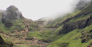
Sani Pass
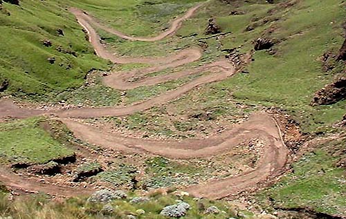
The route up Sani Pass starts at 1544m and climbs 1332 vertical meters to an altitude of 2876m. The road is notoriously dangerous and requires the use of a 4x4 vehicle. The pass lies between the border controls of both countries and is approximately 9 km's in length.
Caution must be exercised and drivers or riders must be alert while navigating the pass as it has claimed many lives. Occasionally the remains of vehicles can be seen that did not succeed in navigating its steep gradients and poor traction surfaces.
Sani Pass to be tarred
2014-05-21 19:53
Durban - The tarring of Sani Pass has been approved by Environmental Affairs Minister Edna Molewa, the KwaZulu-Natal transport department announced on Wednesday.
The road, famed for being a gruelling 4x4 vehicle drive, links Underberg with Mokhotlong.
KwaZulu-Natal transport MEC Willies Mchunu said that the tarring of the road would improve trade relations between South Africa and Lesotho.
http://www.news24.com/SouthAfrica/News/Sani-Pass-to-be-tarred-20140521
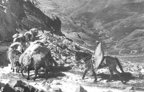
A Pack Train transporting wool and dried peas descending the Pass in 1958
Road Upgrades
An economic impact study of surfacing the Sani Pass Road was compiled in August 2011. An environmental impact assessment for the proposed phase 2 upgrade of the Sani Pass road was compiled in October 2011.
On 2 July 2013 the South African Department of Environmental Affairs and Tourism approved plans to upgrade the road surface on the final 19 km long section leading up to the Lesotho border post over the following three years.
The intention was to re-gravel the final 5km of the pass. The department also authorized plans to upgrade the storm-water drainage system and retaining walls along the route to reduce sand and gravel erosion.
On 21 May 2014 the South African Environmental Affairs Minister, Edna Molewa, approved the tarring of the final 5km stretch of the pass.
The tarring of phase 2 was planned to start within the five months following the announcement and would bring the total cost of phase 2 of the project to R887-million.

Sani Pass Sport
It is one of the few events which takes place in a World Heritage Site (uKhahlamba Drakensberg Park) and is undoubtedly one of the hardest MTB events in Southern Africa. While there are climbs as long and as steep, none of them have the oxygen depleted altitude of Sani Pass. The 42kms event takes cyclists up the fabled Sani Pass, climbing 1674 meters before turning at the top of the Pass and returning to the starting point. Riders have the privilege of riding through the unspoilt beauty, with breathtaking views and lung busting climbs.
Sani Stagger Endurance Race is a tough run; the climb to the Sani Pass Summit is 1300 meters and you do that in just over 20 kilometres. By the time youve reached half way you only would have done 280 meters and the border post is at 1968 meters above sea level. The Sani Stagger has been ranked as a well organised and well presented event and has often been voted as one of the countrys top ten marathons.
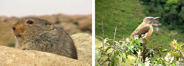
Sani Pass must rank as one of the top ten birding spots in Southern Africa and birding on the Sani Pass is excellent and it's a prime venue for high altitude alpine birding with some 160 bird species being recorded.
Almost every bird encountered is an endemic or a special, including four species not found elsewhere in southern Africa, namely the Drakensberg Rock-jumper, Drakensberg Siskin, Mountain Pipit and the Bearded Vulture. These are birds of limited distribution and this is the easiest place to find them.
A bonus is that Gurney's Sugarbird and Drakensberg Rock-jumper represent two bird families that are endemic to the region, while a number of endemic western species normally associated with the drier karoo are also found in the karoo-like vegetation that occurs right to the top of the pass.
The Sani Pass provides the birder with a uniquely comprehensive and accessible section of uKhahlamba-Drakensberg Park, a world heritage site, habitats from 1600m to 3240m.
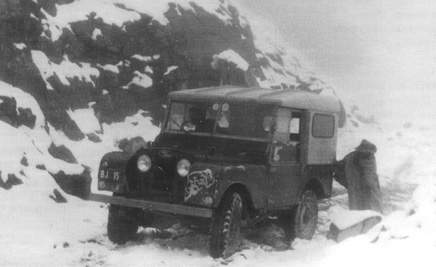
In 1948 the first motor vehicle (a Willy's Jeep) with trailer negotiated the Sani Pass track, driven by Godfrey Edmond of Kokstad, carrying a payload of 900 lbs. It took 14 hours of zigzagging, reversing and manhandling to enable them to complete the journey.
Brother Peppin of the St James Mission also went up and down the track, but with a tractor. In 1955 David Alexander started the first motorised service with one Jeep and six mules. In 1957 the bridle path was converted to an access track for Jeeps.
David Alexander was joined by J. Webb, A. Major and B. Bright and his Mokhotlong Mountain Transport Company (MMT) was formed. This increased trade with Natal and allowed for phenomenal development in Mokhotlong and surrounding areas.
In 1958 they moved the operation to start from Himeville and in 1960 to the present site on the Sani Pass road.
May 1959 saw the great snowfall that blocked the Sani Pass for three months. The heavy rains, lasting for three days, washed away bridges on the South Coast. The road to Underberg was cut off for 24 hours by the floods.

Grace Corner on Sani Pass. Legend has it that in winter, because of the snow and ice, one only got around it by the Grace of God - 1962.
Some History
The severe drought in the early 1930's led to the construction of the bridle path system in Basutoland, instituted to provide work and food for the starving Basuto as well as to open up the mountains. Maj. Harry Smith, the police officer in charge at Mokhotlong in Basutoland, sat on a rock at the top of Sani Pass and without standing up counted 60 dead animals that had died of exhaustion and starvation after climbing the pass. He thus got permission to build the bridle path down into Natal, a distance of ten miles (16km). He accomplished this for the princely sum of 60 pounds. The drought broke in 1933 and this was the beginning of Sani Pass.
The severe drought in the early 1930's led to the construction of the bridle path system in Basutoland, instituted to provide work and food for the starving Basuto as well as to open up the mountains. Maj. Harry Smith, the police officer in charge at Mokhotlong in Basutoland, sat on a rock at the top of Sani Pass and without standing up counted 60 dead animals that had died of exhaustion and starvation after climbing the pass. He thus got permission to build the bridle path down into Natal, a distance of ten miles (16km). He accomplished this for the princely sum of 60 pounds. The drought broke in 1933 and this was the beginning of Sani Pass.

- BED & BREAKFAST
- SELF CATERING
- HOTELS
- BACKPACKERS
- CAMPING